
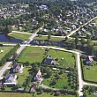
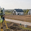
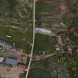
Topographical plan development, all Latvia


Apriņķa mērnieks, LTD
LTD "Apriņka mērnieks" was founded on June 14, 2013 by merging certified surveyors to achieve common goals. The company employs experienced surveyors with certificates "Ģeodēzisko darbu veikšanai", "Kadastrālās uzmērīšanas darbu veikšanai", "Zemes ierīcības darbu veikšanai" .

Meto Pro Group, LTD


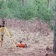
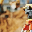
LTD "Meto Pro Group" is a professional surveying company in Riga, providing high-precision surveying, geodesy and topography services throughout Latvia. The company's team has more than 20 years of experience in the industry, which allows it to provide reliable and regulatory-compliant solutions for both individuals and companies.
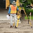
The work process uses the most modern surveying technologies and equipment, which guarantee accurate measurements, fast work execution and high-quality documentation. LTD "Meto Pro Group" also helps clients navigate documentation processes, providing full support from surveying to project implementation.

Gintus, LTD, Surveying

Alūksnes projekti, LTD
LTD "Alūksnes projekti" performs design in Alūksne. Surveying works, boundary plans, making plans, land development projects, topographical surveying. We are engaged in carrying out executive measurements, making schemes, as well as marking building axes. We make measurements accurately and correctly.
GEO Development, Ltd. - certified surveyors, topographical plans

LTD "GEO Development" since 2007. has been providing professional surveying, geodesy, design and geospatial data acquisition services throughout Latvia since. We work with private individuals, construction companies, designers, real estate developers and municipalities.
Our team consists of certified surveyors with many years of experience. We help prepare the necessary surveying documentation for design, construction, property development and commissioning of buildings.
We provide topographic surveying, topographic plans, executive measurements, utility surveying, cadastral surveying, building marking, 3D surveying, laser scanning, aerial photography and GIS solutions.
LTD "GEO Development" offers both standard surveying services and individual solutions for more complex projects. We work with modern technologies and precise surveying methods, ensuring high-quality, reliable results that comply with regulatory requirements.
LTD "GEO Development" is a member of the Latvian Association of Cartographers and Geodesists.

Izpēte, LTD

Rūķis AG, LTD
Surveying office "Rūķis AG" provides various surveying works - topographic measurement, surveying of land borders, development of land development projects and other works.

TP aģentūra, LTD, Surveying
LTD "TP aģentūra" operates in the field of land surveying, land management, border surveying and geodetic works. They provide quality services to customers not only in the Latgale region, but also in the rest of the territory of the Republic of Latvia. The company employs experienced employees who are certified in land cadastral surveying, geodetic works, land development works.

Latvijasmernieks.lv, LTD
LTD "Latvijasmernieks.lv" is one of the leading and most experienced surveying companies for more than 15 years. An excellent, professional team is the key to our success.
Our employees are excellent specialists in their field, certified in all areas of land surveying, so we can offer complex and high-quality solutions.
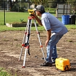
Our specialists use the latest technology in their daily work and our technical equipment includes: electronic manual and robotic tachymeters, digital levels, global navigation satellite system instruments, unmanned aerial vehicle, laser scanner

GEOPOLS, LTD
LTD "GEOPOLS" is a company with many years of experience, which allows us to solve a wide range of projects and problems, as well as to give valuable advice in the bureaucratic jungle of land affairs.

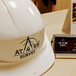
AT SURVEY, LTD
Preime, LTD
Alūksnes projekti, LTD, Branch
LTD "Alūksnes projekti" carries out designing in Awards. Surveying works, boundary plans, making plans, land development projects, topographical surveying. We are engaged in carrying out executive measurements, making schemes, as well as marking building axes. We make measurements accurately and correctly.

VBE, LTD
LTD "VBE" the main areas of activity are the repair of electric motors and electrical devices, as well as surveying, geodesy and cartography. Our company was established on an old and well-known factory "VEF" bases of the electrical engineering department, which was once the pride of Latvia. We have tried to preserve the old "VEF" traditions and technologies, propagating them and incorporating new technologies into the work. But the most important thing is the experience and quality that we guarantee.